The Historical Map Collection of the Suriyakantha Centre: A Visual Journey Through Sri Lanka’s Cartographic Heritage
2023 July 06
By Dr Jacques Soulié
For the child, enamored of maps and prints,
The universe is equal to their vast appetite.
Ah! How grand the world appears in the lamplight!
To the eyes of memory, how small the world seems!
Charles Baudelaire
Cartography — the art of making maps — is deeply rooted in human history. From prehistoric cave paintings to ancient maps of Babylon, Greece, and Asia, through the Age of Discovery and into the 21st century, humans have continually created and relied on maps as essential tools for navigating the world.
Modern cartography in India and Sri Lanka, as developed by Europeans, began five centuries ago. It emerged from a strategic need to ensure the safety of sailors engaged in trade along the Indian coastline. Trade, closely tied to warfare, soon became a major driving force behind map production.
In the 18th and 19th centuries, Sri Lanka occupied a more favorable position than Africa in the history of mapping. Its strategic location at the crossroads of ancient maritime trade routes, combined with its fame for elephants, spices, and gemstones, made it a well-documented region in the writings of Roman, Greek, Persian, and Arab scholars.
The history of ancient maps of Sri Lanka is largely shaped by European maps, produced with the intent to explore, understand, and ultimately dominate the small island kingdom.
The data provided by Claudius Ptolemy — mathematician, astronomer, and geographer of the Alexandrian school — represents the high point of Greek and Roman knowledge of the island then known as Taprobane. His work Geographia, translated into Arabic in the 9th century and rediscovered during the Renaissance, was among the first printed books.
However, during the Age of Discovery, cartography shifted away from the realm of scholars into the hands of merchants, resulting in a culture of secrecy. Maps became strategic assets, and the findings of voyages — whether commercial or political — were closely guarded.
Over the thirteen centuries following Ptolemy, only two known maps of Ceylon were produced: one by the Arab poet and geographer Al-Idrisi, and another by the Venetian monk-cartographer Fra Mauro. The latter provided precise locations and detailed descriptions of what he called the "wonders of Ceylon": the port of Colombo, Adam's Peak, and the island's legendary rubies.
The 17th century marks the beginning of the period covered by the current collection of ancient Sri Lankan maps. Two notable cartographers from that era are Ciprian Sanchez, a Spanish mapmaker employed by the Portuguese (whose map, though published in the 17th century, was likely drawn at the end of the 16th), and Nicolas de Fer, from a family of Amsterdam-based art dealers and engravers. De Fer's map is considered the first to offer detailed topographical information about the island.
Other important contributors include Giovanni Antonio Magini — Italian astronomer, cartographer, and mathematician — whose map of Ceylon was published in London by Robert Knox two years after his escape from captivity in 1680.
French cartographer and military engineer Alain Manesson Mallet began his career in the army of Louis XIV. His contemporary, Guillaume Delisle, regarded as the greatest cartographer of his time, pioneered a more scientific approach to mapping based on mathematics and astronomy.
Dutch mapmaker Isaac Tirion, born in Utrecht, produced several atlases and city plans, often based on Delisle's work.
The Vaugondy family, descendants of Nicolas Sanson — considered one of the fathers of French cartography — continued the family tradition. Didier Robert de Vaugondy was appointed official cartographer to King Louis XV.
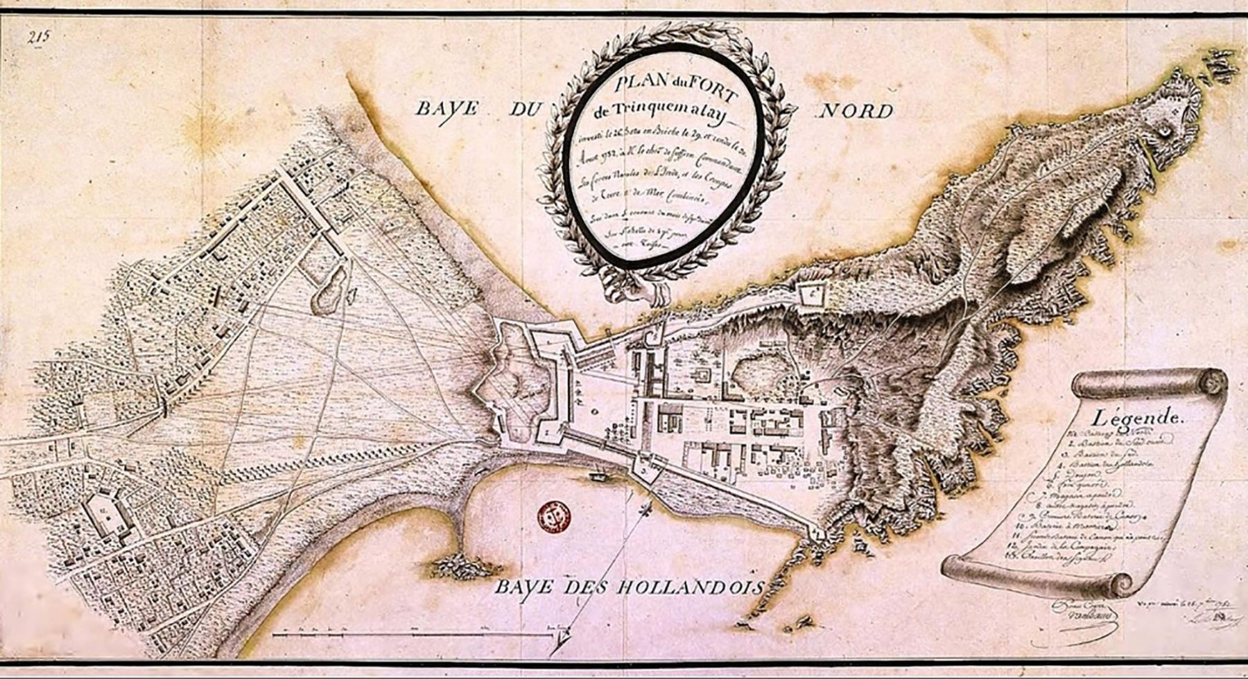
A major figure of the 18th century, Jacques-Nicolas Bellin was one of the most prolific French cartographers of his time. His map of Ceylon, published in the General History of Voyages, is rich with detail: cities such as Colombo, Jaffna, Galle, and Trincomalee, as well as rivers, mountains, and forests. Bellin also authored maritime charts, the map of the Peace of Trincomalee, and the plan of the city and fort of Jaffna.
In the 19th century, Jean-Baptiste Bourguignon d’Anville, sometimes called the "French Strabo," carried on the tradition. A member of the Académie des Inscriptions et Belles-Lettres and the Académie des Sciences, he held a central role in French cartography.
Other notable names include:
- Louis Brion de la Tour, royal cartographer;
- Rigobert Bonne, hydrographer to the King of France;
- Aaron Arrowsmith, a British cartographer and geographer renowned for his high-quality maps and atlases;
- John Rapkin, engraver of the famous map by John Tallis;
- Edward Weller, one of the first to use lithography for map production;
- Charles Dyonnet, a prolific Parisian engraver active in the 19th century, known for some of the most elegant French maps of the era.
Share this article

Comunicato: Suriyakantha lancia la sua prima audioguida a Kandy
2025 September 25